I’ve been working on GeoPackage a bit. GeoPackage is intended to be a format for geospatial data (vectors, tiles and full rasters) that is suitable for use in offline scenarios. To help me understand the specification, I’ve been doing some simple implementation work, mainly on the tiles part. Its called GeoPackage Tools – a highly imaginative name for some tools that work with GeoPackage…
At this stage, there are three command line tools, and some supporting code, all in python. The command line tools
are:
– mb2gpkg, which converts a [MBTiles](http://mbtiles.org) package to GeoPackage
– gpkginfo, which dumps information on the content of a GeoPackage
– gpkg2img, which combines tiles in a GeoPackage to form a composite image
Note that the GeoPackage specification is still in work, and there could be a lot of changes before that specification is complete. These tools are intended to help understand the specification better in terms of implementation issues and functionality. They are not suitable for any kind of “production” use.
The source code is maintained on Launchpad, and configuration management uses bzr. You can find out more about bzr at http://bazaar.canonical.com/en/
To check out the code, just do
bzr branch lp:gpkgtools
There is no need for any installation or build. However you may need to sort out some dependencies. The main dependencies are:
* Python `>= 2.6`
* Python Image Library
* Spatialite (version 3.0.0 or later)
* pysqlite2 that supports extension loading.
Most of those should be easily available, except perhaps the last one. See instructions in the source code README.html for how to deal with this.
Here are some example:
Convert an mbtiles file into a GeoPackage:
./mb2gpkg ~/devel/samples/mbtiles/mapbox.geography-class.mbtiles geography-class.geopackage
The output of that should look something like:
DEBUG:gpkgtools.util_sqlite:Exporting MBTiles to geopackage
DEBUG:gpkgtools.util_sqlite:/home/bradh/devel/samples/mbtiles/mapbox.geography-class.mbtiles --> geography-class.geopackage
DEBUG:gpkgtools.util_sqlite:Creating manifest
DEBUG:gpkgtools.util_sqlite:Completing raster_table_metadata
DEBUG:gpkgtools.util_sqlite:Completing tile_matrix_metadata
DEBUG:gpkgtools.util_sqlite:Completing raster_format_metadata
DEBUG:gpkgtools.util_sqlite:Creating from_mbtiles_tiles
DEBUG:gpkgtools.util_sqlite:Creating from_mbtiles_tiles_rt_metadata
DEBUG:gpkgtools.util_sqlite:Copying data and metadata to geopackage at zoom level:0
DEBUG:gpkgtools.util_sqlite:Copying data and metadata to geopackage at zoom level:1
DEBUG:gpkgtools.util_sqlite:Copying data and metadata to geopackage at zoom level:2
DEBUG:gpkgtools.util_sqlite:Copying data and metadata to geopackage at zoom level:3
DEBUG:gpkgtools.util_sqlite:Copying data and metadata to geopackage at zoom level:4
DEBUG:gpkgtools.util_sqlite:Copying data and metadata to geopackage at zoom level:5
DEBUG:gpkgtools.util_sqlite:Copying data and metadata to geopackage at zoom level:6
DEBUG:gpkgtools.util_sqlite:Copying data and metadata to geopackage at zoom level:7
DEBUG:gpkgtools.util_sqlite:Copying data and metadata to geopackage at zoom level:8
DEBUG:gpkgtools.util_sqlite:Committing results
DEBUG:gpkgtools.util_sqlite:analysing database
DEBUG:gpkgtools.util_sqlite:cleaning database
Dump metadata associated with a GeoPackage
./gpkginfo geography-class.geopackage
Which should result in output like:
Title:              GeoPackage Manifest
Abstract:           Manifest containing references to data tables in this GeoPackage.
Identifier:         geography-class.geopackage.manifest
Metadata
    Abstract:       [Not provided]
    Here:
       BBox:        (-180.0, -85.05112877980659, 180.0, 85.05112877980659)
       href:        geography-class.geopackage
Reference Group
    Abstract:       This ReferenceGroup identifies the contents of a GeoPackage file converted from /home/bradh/devel/samples/mbtiles/mapbox.geography-class.mbtiles
    Identifier:     geography-class.geopackage
    # tables:       1
    TableEntry:     from_mbtiles_tiles
       Type:        tiles
       Version:     2012.05.19
       Identifier:  geography-class.geopackage.from_mbtiles_tiles
       Abstract:    One of the example maps that comes with TileMill - a bright & colorful world map that blends retro and high-tech with its folded paper texture and interactive flag tooltips.
Raster / tile entry:   from_mbtiles_tiles
   title:      Geography Class
   abstract:   One of the example maps that comes with TileMill - a bright & colorful world map that blends retro and high-tech with its folded paper texture and interactive flag tooltips.
   version:    1.0.0
   min_x:      -180.0
   min_y:      -85.0511287798
   max_x:      180.0
   max_y:      85.0511287798
   srid:       3857
   mime type:  image/jpeg
     Compression Quality:  75
     Image representation: RGB (Red, Green, Blue true colour)
     Bit Depth:            24
     Image Category:       VIS
     Image Mode:           N
     Number of bands:      3
   zoomlevel: 0
     tile size:            256 x 256
     tile matrix:          1 x 1
     pixel dimensions:     1.40625 x 0.664461943592
   zoomlevel: 1
     tile size:            256 x 256
     tile matrix:          2 x 2
     pixel dimensions:     0.703125 x 0.332230971796
   zoomlevel: 2
     tile size:            256 x 256
     tile matrix:          4 x 4
     pixel dimensions:     0.3515625 x 0.166115485898
   zoomlevel: 3
     tile size:            256 x 256
     tile matrix:          8 x 8
     pixel dimensions:     0.17578125 x 0.083057742949
   zoomlevel: 4
     tile size:            256 x 256
     tile matrix:          16 x 16
     pixel dimensions:     0.087890625 x 0.0415288714745
   zoomlevel: 5
     tile size:            256 x 256
     tile matrix:          32 x 32
     pixel dimensions:     0.0439453125 x 0.0207644357373
   zoomlevel: 6
     tile size:            256 x 256
     tile matrix:          64 x 64
     pixel dimensions:     0.02197265625 x 0.0103822178686
   zoomlevel: 7
     tile size:            256 x 256
     tile matrix:          128 x 128
     pixel dimensions:     0.010986328125 x 0.00519110893431
   zoomlevel: 8
     tile size:            256 x 256
     tile matrix:          256 x 256
     pixel dimensions:     0.0054931640625 x 0.00259555446716
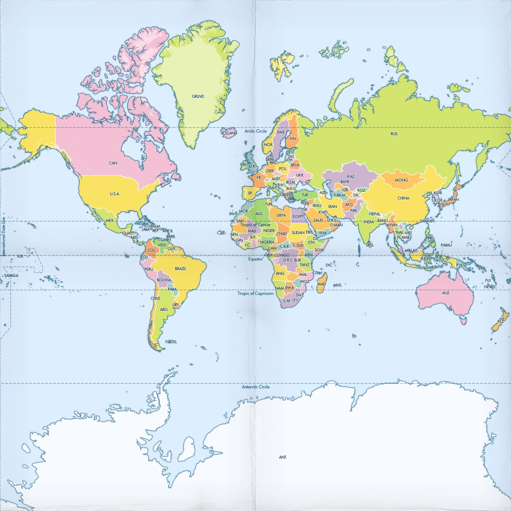
Composite the zoom level three tiles into a single image
./gpkg2img geography-class.geopackage from_mbtiles_tiles 3 geog3.png
Which should product output like:
DEBUG:gpkgtools.util_sqlite:Exporting geopackage tileset to image
DEBUG:gpkgtools.util_sqlite:geography-class.geopackage, from_mbtiles_tiles --> geog3.png
You can open your new image, which should look a bit like